Aerial Photography & Media
Commercial photography, promotional video, tourism, events, visual storytelling, and branded content.

Uncrewed aircraft systems connect aviation with mapping, data, construction, media, public safety, agriculture, inspection, logistics, and autonomous systems. This page helps learners see where those pathways can lead—and where additional training or certification may fit.
The strongest drone careers combine technology with domain expertise—not just aircraft control.
Career exploration should show learners both flight-facing roles and the data, operations, creative, technical, and business roles around them.
Commercial photography, promotional video, tourism, events, visual storytelling, and branded content.
Residential and commercial property imagery, land visualization, development documentation, and facility context.
Venue imagery, sports marketing, event media, facility visualization, outdoor-sport content, and emerging sports-technology applications.
Photogrammetry, orthomosaics, point clouds, surface models, GIS-ready imagery, and change-over-time documentation.
Progress documentation, site visualization, inspection-support imagery, asset awareness, and geospatial workflows.
Environmental observation, agriculture, emergency-response support, research, and community applications.
Fleet operations, hubs, maintenance, data services, delivery networks, UTM, and future BVLOS roles.
Instruction, simulation, curriculum development, career navigation, program coordination, and technical training.
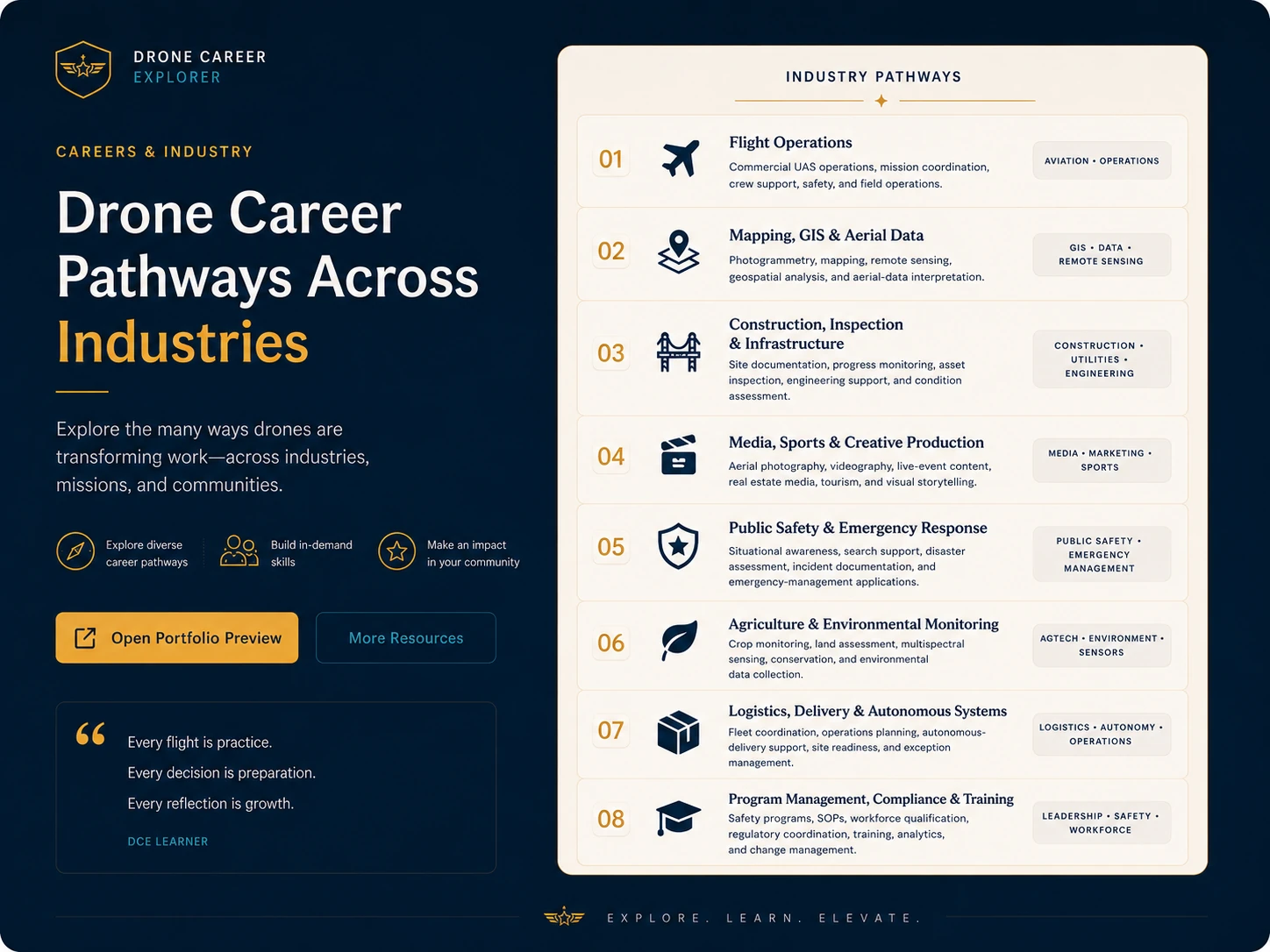
Career clusters Eight ways drone work shows up in industry. These are career families rather than single job titles. Many roles combine drone knowledge with another discipline such as GIS, construction, emergency management, media production, environmental science, or data analysis. 01 Flight Operations Commercial UAS operations, mission coordination, crew support, safety, and field operations. AVIATION • OPERATIONS 02 Mapping, GIS & Aerial Data Photogrammetry, mapping, remote sensing, geospatial analysis, and aerial-data interpretation. GIS • DATA • REMOTE SENSING 03 Construction, Inspection & Infrastructure Site documentation, progress monitoring, asset inspection, engineering support, and condition assessment. CONSTRUCTION • UTILITIES • ENGINEERING 04 Media, Sports & Creative Production Aerial photography, videography, live-event content, real estate media, tourism, and visual storytelling. MEDIA • MARKETING • SPORTS 05 Public Safety & Emergency Response Situational awareness, search support, disaster assessment, incident documentation, and emergency-management applications. PUBLIC SAFETY • EMERGENCY MANAGEMENT 06 Agriculture & Environmental Monitoring Crop monitoring, land assessment, multispectral sensing, conservation, and environmental data collection. AGTECH • ENVIRONMENT • SENSORS 07 Logistics, Delivery & Autonomous Systems Fleet coordination, operations planning, autonomous-delivery support, site readiness, and exception management. LOGISTICS • AUTONOMY • OPERATIONS 08 Program Management, Compliance & Training Safety programs, SOPs, workforce qualification, regulatory coordination, training, analytics, and change management. LEADERSHIP • SAFETY • WORKFORCE
Professional-scope note: Drone imagery can support mapping and geospatial workflows, but boundary surveying and certain regulated surveying, engineering, or professional services may require state licensure or work under a licensed professional.
Commercial drone delivery connects aviation, logistics, safety, airworthiness, data services, infrastructure, environmental planning, and community engagement. That makes it a useful example of how one drone operation can create many different career pathways.
Mission coordination, operations control, crew support, operating procedures, and exception management.
Safety systems, regulatory coordination, documentation, quality assurance, and operational accountability.
Aircraft condition, maintenance governance, technical records, reliability, and continued operational safety.
Site readiness, loading workflows, fleet coordination, inventory movement, charging, and delivery infrastructure.
Airspace-status data, traffic-management services, communications coverage, conformance monitoring, and system integration.
Local coordination, public communication, land-use considerations, environmental review, noise, and community trust.
The FAA says Part 135 is the current air-carrier pathway for commercial small-package delivery, with additional authorizations and regulatory relief required for BVLOS operations as applicable.
At least eight U.S. companies now hold FAA Part 135 air-carrier certification for drone package delivery, most recently DoorDash in July 2026. Their work spans food, medicine, retail packages, healthcare logistics, and on-demand delivery.
Examples are shown for career and industry awareness, not endorsement.
View FAA Operator ListIndustry trends should be treated as a moving picture. These indicators are sourced from public FAA and U.S. Bureau of Labor Statistics information and should be refreshed periodically.
Commercial UAS package delivery currently uses Part 135 air-carrier certification, while the final BVLOS rule (proposed Part 108) has been under White House review since July 2026.
FAA package-delivery overview →On August 27, 2026, the FAA announced BEYOND Phase 2 would add up to eight new lead participants as it continues work on advanced drone integration, including operations beyond visual line of sight.
FAA BEYOND program →BLS projects 7% employment growth for cartographers and photogrammetrists from 2025 to 2035, with about 900 openings per year; the median annual wage was $81,390 in May 2025. These figures describe that occupation—not every drone-related role.
BLS occupation profile →Surveyor employment is projected to grow 6% from 2025 to 2035. BLS notes that drones improve efficiency, while professionals still review and interpret outputs for accuracy and completeness.
BLS surveyor profile →The FAA UAS Collegiate Training Initiative recognizes colleges, universities, and technical schools that prepare students for careers in UAS and connects them with government and industry stakeholders.
FAA UAS-CTI →Drone Career Explorer offers program-issued certificates of completion for defined learning pathways. These educational credentials are separate from FAA aviation certification. For commercial small-UAS operations under Part 107, the FAA issues the Remote Pilot Certificate. Students may begin learning earlier, but FAA eligibility for a first-time Part 107 Remote Pilot Certificate begins at age 16.
Learners can earn program certificates after completing defined pathway and evidence requirements, while educators can earn a microcredential through professional learning and implementation evidence.
View Standards & CredentialsThis is the federal credential for operating a small drone under the FAA's Part 107 rules. Schools and training providers may help students prepare, but the certificate itself is issued by the FAA.
Review FAA Part 107Use the FAA's national directory to identify colleges and technical schools recognized for UAS career preparation.
Open FAA School DirectoryThese are examples, not endorsements. Offerings, costs, schedules, and admission requirements change, so learners should verify current information directly with each institution.
FAA UAS-CTI participant with a 7-credit Drone Essentials Certificate and a 16-credit Drone Technology and Applications Certificate covering operations, flight skills, aerial data, mapping/GIS, and media applications.
A 5-credit Drone Pilot Operator Certificate that can be completed in one semester and prepares students for the FAA Recreational UAS Safety Test (TRUST) and the Part 107 knowledge test.
A one-year UAS technical certificate with pathways that include GIS, aerial sensing/data analytics, precision agriculture, and first-responder applications.
An 18-credit undergraduate certificate in Uncrewed Systems Technology, with additional associate, bachelor's, and graduate pathways in uncrewed and autonomous systems.
A school does not need to become a certification provider to create a strong pathway. Drone Career Explorer helps students discover the field, build foundational knowledge, connect classroom learning with simulation opportunities where available, and identify postsecondary or FAA-recognized pathways.
Use the FAA UAS-CTI directory to identify nearby colleges, universities, and technical programs.
Invite postsecondary faculty, UAS professionals, or an FAA DronePro to speak, demonstrate careers, or support an awareness event.
Connect classroom projects to campus visits, simulation experiences, summer programs, dual-enrollment opportunities where available, and certification preparation when appropriate.